Stockholm is enacting policies to both mitigate and prepare for the effects of climate change, including a goal to be fossil fuel free by 2050 and the adaptation of building codes for a warmer wetter climate. Within 20-30 years, Stockholm is expecting 150,000 new residents, and within 50 years, a 4-6 deg C. increase in average temperature (compare to Barcelona today) and a 1-2 month extended growing season.
We proposed to a build a new city for 150,000 people, on an agricultural peninsula near Kungsängen, 30 min from Stockholm by commuter rail. The new community would serve as a prototype, mixing urban commuters from Stockholm, and climate refugees with agrarian skills, creating a working model for a new Productive City.
Simulation
Initialization of the Kungsängen site involved identifying landscape components as developable, protected and/or attractors. The proposed site is 9km2, bounded on the north by a commuter train line/station and the existing town (attractors). The eastern boundary is waterfront (attractor), while south and west is primarily wooded waterfront (protected).
The Settlement Simulation was built for 1km2 field so for this site a scaling strategy was developed, in which the site is built up in sequential 1km2 tiles, taking initialization data from the boundary of each previous tile. Tiles were assigned different Density (D) and Friendliness (F) values providing residents a choice in varying spatial characters city-wide.
Kungsängen growth is simulated in tiles, as a lower resolution cellular automata.
Network
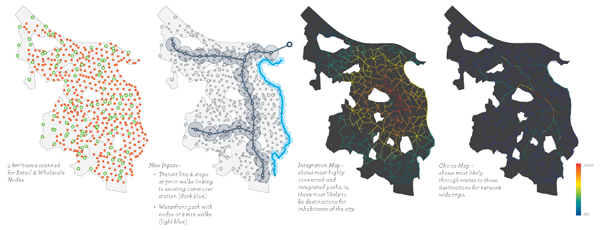
As the Kungsängen site will serve as a satellite city to Stockholm, the commuter link is of prime importance in the network strategy. Therefore once wholesale and retail nodes were located, a transit spine was placed, linking our site to the commuter train station with nodes every 400m (5 min walks) Transit nodes checked for nearby Wholesale nodes, and if within range, they were merged. Additionally a waterfront path was input with nodes for public space. All nodes were subsequently linked, nodes and paths analyzed and ranked, and pubic program area assigned.
Wholesale and retail nodes were placed, distribution network was generated, and paths are analyzed for integration and in-between-ness, and ranked from 0% to 100%.
Blocks across the different tiles exhibit much more variation in size than in our 1km2 tissue, resulting from the different combinations of Density and Friendliness. Larger blocks are also lower in population density providing a different urban character than those within our denser more central tiles.
The natural features of the site were integrated into the recreational network by allowing recreational nodes within the blocks to connect to protected forests and public waterfront.
Typologies Informed by Climate
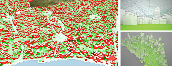
In a colder climate with a shorter growing season, it’s expected that there will be a heavier reliance on greenhouses. We proposed, for Kungsängen, a ‘Greenhouse Block’ type, enclosing the commons and dwellings around the block perimeter.
A network of productive public spaces (left). Greenhouse block type (right).


