The previously generated network edges will become the primary urban circulation paths and will need to support the full complement of public urban programs including Social Mixing (retail, entertainment, institutions and workspaces), Transport, and Recreation/Gathering (urban squares and green spaces).
Topological analysis informs the program types and area assigned to each network component. Highly connected nodes and paths serve larger volumes of traffic and are stronger attractors for social mixing programs such as retail, food, drink and entertainment uses.
Wholesale and Retail Nodes
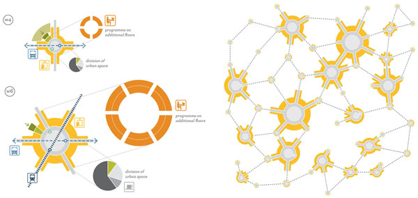
Wholesale and Retail are categorized according to the number of connections from W/R1 to W/R6 and classified as ‘Minor Hubs’ (W4) ‘Major Hubs’(W5+) Local Nuclei (R4) and so on.
Nodes are identified and ranked according to the number of connections.
Program space is allocated accordingly. Highest connected nodes are designated a total open space of 10,000 m2, comparable to Leicester Square, London (8000 m2). This area is further broken down into circulation, production, outdoor eating/drinking and unprogrammed open space. These programs are then scaled for each node type/rank. (Semi)-private space for social mixing programs is allocated in the surrounding storefronts below dwellings, ensuring mixed use and density is maintained.
Public program types and areas are allocated according to node connectivity.
Network Paths
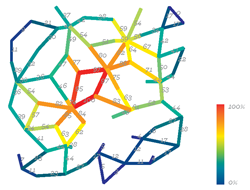
Paths are analyzed and ranked by their integration value, which measures the likelihood of a path to be a destination for trips within the network. Highly integrated paths are most likely to be intensely trafficked, therefore become market streets with retail frontages and farmers’ markets. Low integrated paths will be quieter, tending toward residential uses and small corner grocers.
Paths are analyzed for connectivity and integration, and ranked form 0% to 100%.
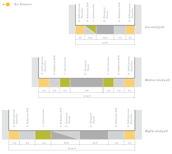
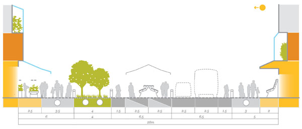
Each path is allocated space, in section, for four types of program zones:
• Public/Private Transition
• Pedestrian Paths
• Infrastructure (both traditional and edible)
• Transport/Transit
These will later be populated from a library of sectional program components. The range of widths and relative location of the zones is determined by the path integration ranking – low, medium and high.
Typical program zones assigned by integration rating.
Path components applied on a highly integrated path (typical).
With program space assigned to paths across the tissue, a distinct hierarchy of streets becomes evident. The highly integrated paths suggest a market street or neighborhood retail core. Lower integrated streets generate less intense and narrower streets, suggesting lower intensity, primarily residential streets.
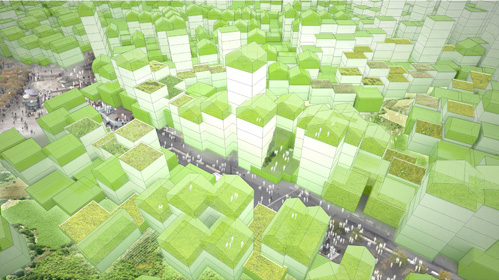
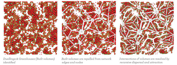
With public space and programming of the circulatory network allocated, the built morphology must respond accordingly. Dwelling cells are cleared from nodes and paths and then attracted back in a series of recursive ‘packing’ steps, creating contiguous streetscapes and defined urban void spaces.
Network paths are first cleared according to program area, then become attractors for built units.

